

PhD
Doctoral programmes
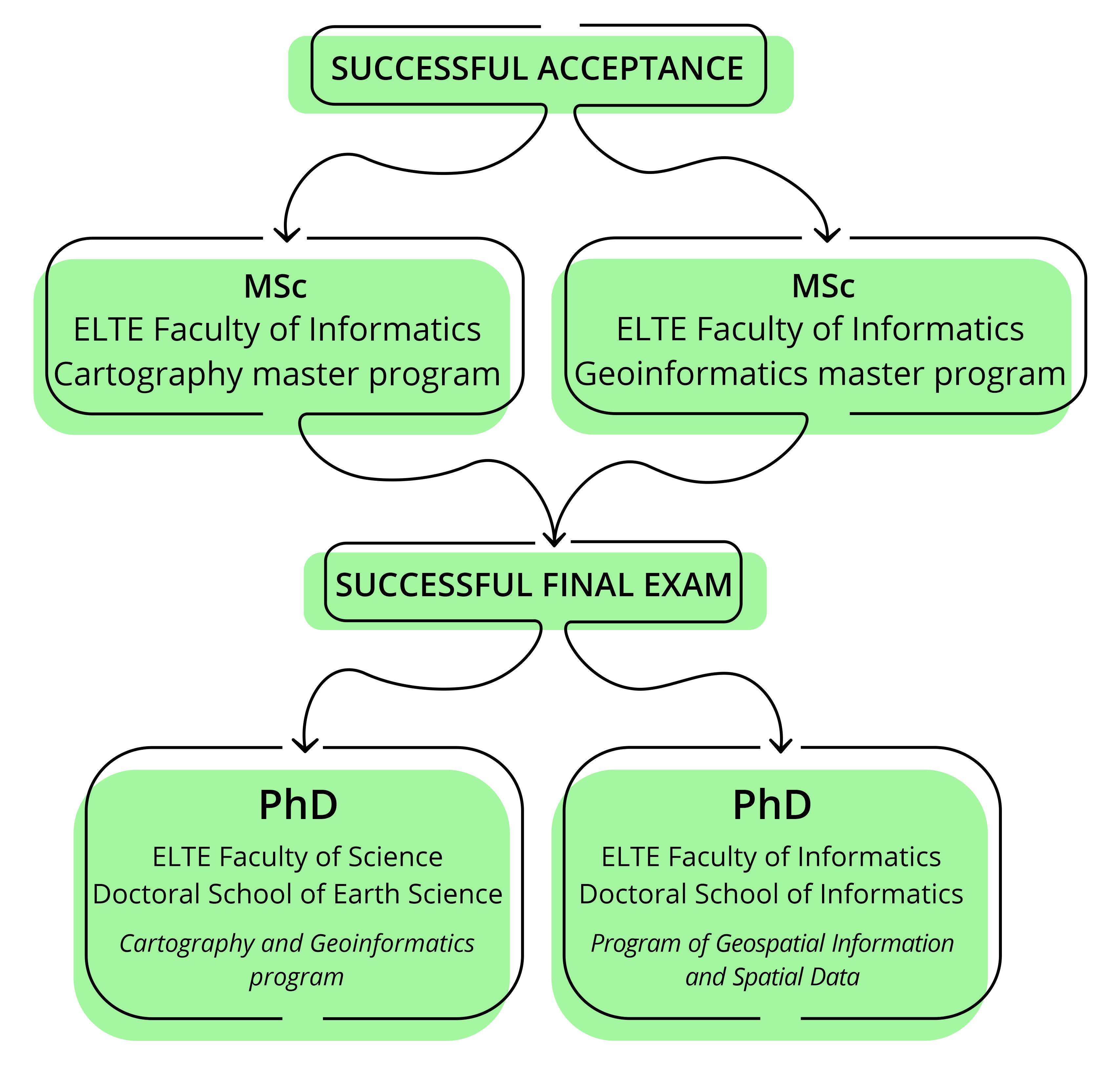
Doctoral studies (PhD) are the highest level of education, aiming to broaden scientific knowledge and prepare students for their doctoral degree. You can apply after obtaining your Master's degree.
The PhD is a mix of study, research and reporting activity, and it involves the fulfilment of obligations laid down in the University's doctoral regulations. The duration of the training is a 2+2 years. Following the PhD studies, the doctoral degree can be obtained through a degree-granting procedure.
In Hungary, doctoral training is provided by doctoral schools, which coordinate the doctoral programmes of universities, the work of doctoral students and take care of the professional and administrative aspects of the training.The training can be funded by the a scholarship programme or self-paid.
Our Institute offers two programmes:
In the field of cartography, such a course can be applied for in the Cartography-Geoinformatics programme of the Doctoral School of Earth Sciences of the ELTE Faculty of Natural Sciences. Applications are accepted from March each year. Admission is usually announced in early July (this allows for applications from recent Masters graduates). The most important element of the application is the selection of a suitable research topic and a corresponding topic leader. In the field of cartography, the topic leader can be a senior lecturer in the Department of Cartography and Geoinformatics (professor, associate professor or adjunct professors who have accreditation as a topic leader). For more information, please visit the Doctoral School website.
In the field of spatial informatics, the doctoral programme in Spatial Informatics and Spatial Data Science of the ELTE Faculty of Informatics Doctoral School of Informatics is open for applications from 2024.
Spatial data is one of the raw materials of social and industrial digitalisation, and a key input parameter for many economic and research development concepts.The status and successful use of spatial data (spatially, temporally, thematically) is a measure of value, both from a scientific and economic point of view. A significant part of information on human culture is also spatial data. The PhD programme in Spatial Informatics and Spatial Data Science aims at the scientific analysis, interpretation and modelling of the spatial context of attribute data. The programme aims to develop the theoretical and practical understanding, application and research development of spatial data technologies needed to understand the challenges outlined. Thematic areas of the doctoral programme include: remote sensing methods, web-GIS, navigation and mobile mapping technologies, spatial data visualisation, spatial data mining and other related technical computing topics. For more information, please visit the Doctoral School website.
A list of doctoral topics, supervisors and lecturers is available at www.doktori.hu (for all Hungarian doctoral programmes).
In the admission procedure, the following criteria are taken into account in allocating the number of scholarship places to the doctoral schools, and the applicants are ranked according to these criteria:
- topic outline
- degree (applicants with a degree other than a master's degree in cartography may also apply)
- publication activity (articles, studies, conference presentations)
- scientific student activities
- awards (e.g. outstanding student of the faculty)
As these are usually "extra points" that can be obtained as a result of several years of activity, it is advisable for those interested in doctoral studies to prepare themselves for applying for doctoral studies as soon as they start their Master's degree.
Other useful websites
Doctoral training programme can be found here. Find Doctoral School of Earth Sciences and Doctoral School of Informatics.
Documents of doctoral schools can be downloaded from here.
List of our PhD Students with their topics.
If you are interested, please contact the heads of the doctoral programmes, Professor László ZENTAI, Professor, and Professor András JUNG.
>> Click here for scholarship programmes and doctoral application information. <<
Scholarships are also available, read more here.